Appalachian Trail Shelters

Shelter miles next elev. County State Waypoint
Black Gap Shelter 1.5 -1.3 3300' Gilmer GA BlackGap
Springer Mountain Shelter 0.2 2.6 3730' Fannin GA Springer
Stover Creek Shelter 2.8 5.3 2870' Fannin GA StoverCrk
Hawk Mountain Shelter 8.1 7.7 3200' Union GA HawkMtn
Gooch Mountain Shelter 15.8 12.3 3000' Union GA GoochMtn
Woods Hole Shelter 28.1 1.2 3600' Union GA WoodsHole
Blood Mountain Shelter 29.3 9.1 4450' Lumpkin GA BloodMtn
Whitley Gap Shelter 38.4 4.8 3370' White GA WhitleyG
Low Gap Shelter 43.2 7.3 3050' White GA LowGap
Blue Mountain Shelter 50.5 8.1 3900' Towns GA BlueMtn
Tray Mountain Shelter 58.6 7.4 4200' Habersham GA TrayMtn
Deep Gap Shelter 66.0 8.1 3550' Rabun GA DeepGap
Plumorchard Gap Shelter 74.1 7.3 3050' Towns GA Plumorchar
Muskrat Creek Shelter 81.4 4.9 4600' Clay NC MuskratCr
Standing Indian Shelter 86.3 7.6 4760' Macon NC StandingI
Carter Gap Shelter (old) 93.9 off 4540' Macon NC CarterG1
Carter Gap Shelter (new) 93.9 6.8 4540' Clay NC CarterG2
Big Spring Shelter 100.7 5.3 4940' Macon NC BigSpring
Rock Gap Shelter 106.0 8.0 3760' Macon NC RockGap
Siler Bald Shelter 114.0 6.8 4600' Macon NC SilerBald
Wayah Shelter 120.8 4.8 4759' Macon NC Wayah
Cold Spring Shelter 125.6 5.8 4920' Macon NC ColdSpr
Wesser Bald Shelter 131.4 4.9 4115' Macon NC WesserBal
A. Rufus Morgan Shelter 136.3 7.7 2300' Swain NC ARufusM
Sassafras Gap Shelter 144.0 9.1 4330' Swain NC Sassafras
Brown Fork Gap Shelter 153.1 6.1 3800' Graham NC BrownFork
Cable Gap Shelter 159.2 6.6 2880' Graham NC CableGap
Fontana Dam Shelter 165.8 11.0 1775' Graham NC Fontana
Mollies Ridge Shelter 176.8 2.8 4570' Blount TN MolliesR
Russell Field Shelter 179.6 2.9 4360' Blount TN RussellFi
Spence Field Shelter 182.5 6.3 4915' Swain NC SpenceFld
Derrick Knob Shelter 188.8 5.5 4880' Sevier TN DerrickKn
Silers Bald Shelter 194.3 1.7 5460' Swain NC SilersBal
Double Spring Gap Shelter 196.0 6.3 5505' Swain NC DoubleSp1
Mt. Collins Shelter 202.3 7.2 5870' Sevier TN MtCollin
Mount Le Conte Shelter 209.5 off 6440' Sevier TN MtLeCont
Icewater Spring Shelter 209.8 7.4 5920' Swain NC Icewater
Pecks Corner Shelter 217.2 5.2 5280' Swain NC PecksCorn
Tricorner Knob Shelter 222.4 7.7 5920' Swain NC Tricorner
Cosby Knob Shelter 230.1 7.1 4740' Haywood NC CosbyKnob
Davenport Gap Shelter 237.2 10.5 2600' Cocke TN Davenport
Groundhog Creek Shelter 247.7 8.2 2850' Haywood NC Groundhog
Roaring Fork Shelter 255.9 4.9 3590' Madison NC RoaringFo
Walnut Mountain Shelter 260.8 9.9 4260' Cocke TN WalnutMtn
Deer Park Mountain Shelter 270.7 14.2 2330' Madison NC DeerPark
Spring Mountain Shelter 284.9 8.6 3300' Greene TN SpringMtn
Little Laurel Shelter 293.5 6.8 3620' Madison NC LittleLrl
Jerry Cabin 300.3 5.9 4150' Madison NC JerryCabi
Flint Mountain Shelter 306.2 8.8 3570' Madison NC FlintMtn
Hogback Ridge Shelter 315.0 10.1 4255' Madison NC HogbackR
Bald Mountain Shelter 325.1 10.6 5100' Unicoi TN BaldMtn
No Business Knob Shelter 335.7 10.5 3180' Unicoi TN NoBusines
Curley Maple Gap Shelter 346.2 12.8 3070' Unicoi TN CurleyMap
Cherry Gap Shelter 359.0 9.2 3900' Unicoi TN CherryGap
Clyde Smith Shelter 368.2 7.2 4400' Carter TN ClydeSmit
Roan High Knob Shelter 375.4 5.4 6275' Carter TN RoanHigh
Stan Murray Shelter 380.8 1.9 5050' Avery NC StanMurra
Overmountain Shelter 382.7 8.7 4550' Avery NC Overmounta
Apple House Shelter 391.4 9.3 3000' Carter TN AppleHous
Mountaineer Falls Shelter 400.7 9.6 3200' Carter TN Mountainee
Moreland Gap Shelter 410.3 7.9 3815' Carter TN MorelandG
Laurel Fork Shelter 418.2 8.6 2450' Carter TN LaurelFrk
Watauga Lake Shelter 426.8 7.2 2130' Carter TN WataugaLk
Vandeventer Shelter 434.0 6.8 3620' Carter TN Vandevente
Iron Mountain Shelter 440.8 7.6 4125' Johnson TN IronMount
Double Springs Shelter 448.4 8.3 4060' Carter TN DoubleSp2
Abingdon Gap Shelter 456.7 10.0 3785' Johnson TN AbingdonG
The Place 466.7 9.6 1928' Washington VA ThePlace
Saunders Shelter 476.3 6.4 3310' Washington VA Saunders
Lost Mountain Shelter 482.7 12.2 3360' Washington VA LostMtn
Thomas Knob Shelter 494.9 5.1 5400' Grayson VA ThomasKnb
Wise Shelter 500.0 5.9 4460' Grayson VA Wise
Old Orchard Shelter 505.9 5.0 4050' Grayson VA OldOrchar
Hurricane Mountain Shelter 510.9 6.7 3850' Grayson VA Hurricane
Raccoon Branch camp 517.6 2.4 3570' Smyth VA RaccoonBr
Trimpi Shelter 520.0 10.6 2900' Smyth VA Trimpi
Partnership Shelter 530.6 7.1 3360' Smyth VA Partnershi
Chatfield Shelter 537.7 7.2 3150' Smyth VA Chatfield
Davis Path camp 544.9 11.2 2840' Smyth VA DavisPath
Knot Maul Branch Shelter 556.1 9.1 2880' Bland VA KnotMaul
Chestnut Knob Shelter 565.2 10.0 4409' Tazewell VA ChestnutK
Jenkins Shelter 575.2 14.0 2500' Bland VA Jenkins
Helveys Mill Shelter 589.2 9.8 3090' Bland VA HelveysM
Jenny Knob Shelter 599.0 14.2 2800' Bland VA JennyKnob
Wapiti Shelter 613.2 8.4 2640' Giles VA Wapiti
Docs Knob Shelter 621.6 15.0 3555' Giles VA DocsKnob
Rice Field Shelter 636.6 12.5 3375' Giles VA RiceField
Pine Swamp Branch Shelter 649.1 3.9 2530' Giles VA PineSwpB
Bailey Gap Shelter 653.0 8.8 3525' Giles VA BaileyGap
War Spur Shelter 661.8 5.8 2340' Giles VA WarSpur
Laurel Creek Shelter 667.6 6.4 2720' Craig VA LaurelCrk
Sarver Hollow Shelter 674.0 6.0 3000' Montgomery VA SarverHoll
Niday Shelter 680.0 10.1 1800' Craig VA Niday
Pickle Branch Shelter 690.1 13.6 1845' Craig VA PickleBr
Johns Spring Shelter 703.7 1.0 1980' Roanoke VA BoyScout
Catawba Mountain Shelter 704.7 2.4 2580' Roanoke VA Catawba
Campbell Shelter 707.1 6.0 2580' Roanoke VA Campbell
Lamberts Meadow Shelter 713.1 14.4 2080' Botetourt VA LambertsM
Fullhardt Knob Shelter 727.5 6.2 2670' Botetourt VA Fullhardt
Wilson Creek Shelter 733.7 7.3 1830' Botetourt VA WilsonCrk
Bobblets Gap Shelter 741.0 6.5 1920' Botetourt VA BobbletsG
Cove Mountain Shelter 747.5 7.0 1925' Botetourt VA CoveMtn1
Bryant Ridge Shelter 754.5 4.9 1320' Botetourt VA BryantRdg
Cornelius Creek Shelter 759.4 5.3 3145' Botetourt VA Cornelius
Thunder Hill Shelter 764.7 12.4 3960' Bedford VA ThunderHi
Matts Creek Shelter 777.1 3.9 835' Bedford VA MattsCrk
Johns Hollow Shelter 781.0 8.8 1020' Amherst VA JohnsHoll
Punchbowl Shelter 789.8 9.5 2500' Amherst VA Punchbowl
Brown Mountain Creek Shelter 799.3 5.6 1395' Amherst VA BrownMtn
Cow Camp Shelter 804.9 10.2 3160' Amherst VA CowCamp
Seeley-Woodworth Shelter 815.1 6.6 3770' Nelson VA SeeleyWoo
The Priest Shelter 821.7 7.6 3840' Nelson VA ThePriest
Harpers Creek Shelter 829.3 6.2 1800' Nelson VA HarpersCr
Maupin Field Shelter 835.5 15.8 2720' Nelson VA MaupinFld
Paul C. Wolfe Shelter 851.3 12.0 1700' Nelson VA PaulCWo
Calf Mountain Shelter 863.3 13.0 2700' Augusta VA CalfMtn
Blackrock Hut 876.3 13.2 2645' Albemarle VA Blackrock
Pinefield Hut 889.5 8.2 2430' Greene VA Pinefield
Hightop Hut 897.7 12.4 3175' Rockingham VA Hightop
Bearfence Mountain Hut 910.1 11.5 3110' Greene VA Bearfence
Rock Spring Hut 921.6 10.9 3465' Page VA RockSpr
Byrds Nest 3 932.5 4.4 3290' Page VA ByrdsNst
Pass Mountain Hut 936.9 13.1 2690' Rappahannock VA PassMtn
Gravel Springs Hut 950.0 10.5 2480' Rappahannock VA GravelSpr
Tom Floyd Wayside Shelter 960.5 8.1 1900' Warren VA TomFloyd
Jim n Molly Denton Shelter 968.6 5.5 1310' Warren VA JimMoll
Manassas Gap Shelter 974.1 4.5 1655' Fauquier VA ManassasG
Dicks Dome Shelter 978.6 8.4 1230' Fauquier VA DicksDom
Rod Hollow Shelter 987.0 6.9 840' Clarke VA RodHollow
Sam Moore Shelter 993.9 3.0 990' Clarke VA SamMoore
Bears Den Hostel 996.9 7.9 1350' Clarke VA BearsDen
Blackburn Trail Center 1004.8 3.2 1400' Loudoun VA Blackburn
David Lesser Shelter 1008.0 15.6 1380' Loudoun VA DavidLess
Ed Garvey Shelter 1023.6 4.1 1100' Washington MD EdGarvey
Crampton Gap Shelter 1027.7 5.0 1000' Frederick MD CramptonG
Rocky Run Shelter 1032.7 7.5 970' Washington MD RockyRun
Pine Knob Shelter 1040.2 8.2 1360' Washington MD PineKnob
Ensign Cowall Shelter 1048.4 4.9 1430' Washington MD EnsignCow
Devils Racecourse Shelter 1053.3 9.6 1480' Washington MD DevilsRac
Deer Lick Shelters 1062.9 2.4 1420' Franklin PA DeerLick
Antietam Shelter 1065.3 1.2 890' Franklin PA Antietam
Tumbling Run Shelters 1066.5 6.6 1120' Franklin PA TumblingR
Rocky Mountain Shelters 1073.1 5.6 1520' Franklin PA RockyMtn
Quarry Gap Shelters 1078.7 7.4 1455' Franklin PA QuarryGap
Birch Run Shelters 1086.1 6.2 1795' Cumberland PA BirchRun
Toms Run Shelters 1092.3 10.9 1300' Cumberland PA TomsRun
James Fry Shelter 1103.2 8.1 805' Cumberland PA JamesFry
Alec Kennedy Shelter 1111.3 18.2 850' Cumberland PA AlecKenne
Darlington Shelter 1129.5 7.3 1170' Perry PA Darlington
Thelma Marks Shelter 1136.8 8.6 1120' Perry PA ThelmaM
Clarks Ferry Shelter 1145.4 6.7 1180' Dauphin PA ClarksFer
Peters Mountain Shelter 1152.1 18.0 970' Dauphin PA PetersMtn
Rausch Gap Shelter 1170.1 13.4 970' Lebanon PA RauschGap
William Penn Shelter 1183.5 4.1 1300' Berks PA WilliamPe
501 Shelter 1187.6 15.1 1460' Berks PA 501Shltr
Eagles Nest Shelter 1202.7 14.7 1510' Schuylkill PA EaglesNes
Windsor Furnace Shelter 1217.4 9.1 880' Berks PA WindsorFu
Eckville Shelter 1226.5 7.4 535' Berks PA Eckville
Allentown Shelter 1233.9 10.0 1350' Lehigh PA Allentown
Bake Oven Knob Shelter 1243.9 6.8 1380' Lehigh PA BakeOven
George W. Outerbridge Shelter 1250.7 16.7 1000' Lehigh PA GeorgeW
Leroy A. Smith Shelter 1267.4 13.8 1410' Monroe PA LeroyAS
Kirkridge Shelter 1281.2 31.2 1480' Northampton PA Kirkridge
Brink Road Shelter 1312.4 6.6 1110' Sussex NJ BrinkRoad
Gren Anderson Shelter 1319.0 5.8 1320' Sussex NJ GrenAnder
Mashipacong Shelter 1324.8 2.9 1425' Sussex NJ Mashipacon
Rutherford Shelter 1327.7 4.3 1345' Sussex NJ Rutherford
High Point Shelter 1332.0 12.4 1280' Sussex NJ HighPoint
Pochuck Mountain Shelter 1344.4 11.5 840' Sussex NJ PochuckMt
Wawayanda Shelter 1355.9 12.1 1200' Sussex NJ Wawayanda
Wildcat Shelter 1368.0 14.3 1180' Orange NY Wildcat
Fingerboard Shelter 1382.3 5.3 1300' Orange NY Fingerboar
William Brien Memorial Shelter 1387.6 3.1 1070' Orange NY WilliamBr
West Mountain Shelter 1390.7 32.2 1240' Rockland NY WMtn
RPH Shelter 1422.9 9.0 360' Dutchess NY RPH
Morgan Stewart Memorial Shelter 1431.9 7.8 1285' Dutchess NY MorganSte
Telephone Pioneers Shelter 1439.7 8.8 910' Dutchess NY Telephone
Wiley Shelter 1448.5 4.0 740' Dutchess NY Wiley
Ten Mile River Lean-to 1452.5 8.4 290' Fairfield CT TenMileR
Mt. Algo Lean-to 1460.9 7.3 655' Litchfield CT MtAlgo
Stewart Hollow Brook Lean-to 1468.2 10.0 425' Litchfield CT StewartHo
Pine Swamp Brook Lean-to 1478.2 12.3 1075' Litchfield CT PineSBrk
Limestone Spring Lean-to 1490.5 7.5 980' Litchfield CT Limestone
Riga Lean-to 1498.0 1.2 1610' Litchfield CT Riga
Brassie Brook Lean-to 1499.2 8.8 1705' Litchfield CT BrassieBr
The Hemlocks Lean-to 1508.0 0.1 1880' Berkshire MA TheHemloc
Glen Brook Lean-to 1508.1 14.3 1885' Berkshire MA GlenBrook
Tom Leonard Lean-to 1522.4 5.3 1540' Berkshire MA TomLeonar
Mt. Wilcox South Lean-to 1527.7 1.8 1720' Berkshire MA MtWilcoxS
Mt. Wilcox North Lean-to 1529.5 14.0 1950' Berkshire MA MtWilcoxN
Upper Goose Pond Cabin 1543.5 8.8 1483' Berkshire MA UpperGoos
October Mountain Lean-to 1552.3 8.8 1930' Berkshire MA OctoberMt
Kay Wood Lean-to 1561.1 16.9 1860' Berkshire MA KayWood
Mark Noepel Lean-to 1578.0 3.3 2750' Berkshire MA MarkNoepe
Bascom Lodge 1581.3 3.3 3491' Berkshire MA BascomLdg
Wilbur Clearing Lean-to 1584.6 9.9 2325' Berkshire MA WilburClr
Seth Warner Shelter 1594.5 7.2 2180' Bennington VT SethWarne
Congdon Shelter 1601.7 5.9 2060' Bennington VT Congdon
Melville Nauheim Shelter 1607.6 8.5 2330' Bennington VT MelvilleN
Goddard Shelter 1616.1 4.3 3540' Bennington VT Goddard
Kid Gore Shelter 1620.4 off 2795' Bennington VT KidGore
Caughnawaga Shelter 1620.4 4.6 2795' Bennington VT Caughnawag
Story Spring Shelter 1625.0 10.4 2810' Bennington VT StorySpr
Stratton Pond Shelter 1635.4 4.9 2565' Windham VT StrattonP
William B. Douglas Shelter 1640.3 3.0 2210' Bennington VT WilliamB
Spruce Peak Shelter 1643.3 4.8 2180' Bennington VT SprucePea
Bromley Shelter 1648.1 8.1 2560' Bennington VT Bromley
Peru Peak Shelter 1656.2 4.7 2605' Bennington VT PeruPeak
Lost Pond Shelter 1660.9 1.5 2150' Bennington VT LostPond
Old Job Shelter 1662.4 0.2 1525' Rutland VT OldJob
Big Branch Shelter 1662.6 3.0 1460' Rutland VT BigBranch
Lula Tye Shelter 1665.6 0.3 1920' Rutland VT LulaTye
Little Rock Pond Shelter 1665.9 4.8 1885' Rutland VT LittleRoc
Greenwall Shelter 1670.7 5.1 2025' Rutland VT Greenwall
Minerva Hinchey Shelter 1675.8 3.7 1605' Rutland VT MinervaHi
Clarendon Shelter 1679.5 5.8 1190' Rutland VT Clarendon
Governor Clement Shelter 1685.3 4.3 1900' Rutland VT GovernorC
Cooper Lodge 1689.6 2.5 3850' Rutland VT CooperLdg
Pico Camp Shelter 1692.1 1.9 3510' Rutland VT PicoCamp
Churchill Scott Shelter 1694.0 2.9 2560' Rutland VT Churchill
Tucker Johnson removed 1696.9 2.3 2300' Rutland VT TuckerJoh
Gifford Woods State Park 1699.2 6.7 1660' Rutland VT GiffordW
Stony Brook Shelter 1705.9 9.9 1760' Windsor VT StonyBrk
Wintturi Shelter 1715.8 9.8 1910' Windsor VT WintturiS
Cloudland Shelter 1725.6 ? 1480' Windsor VT Cloudland
Thistle Hill Shelter 1727.4 8.8 1680' Windsor VT ThistleHi
Happy Hill Shelter 1736.2 7.3 1420' Windsor VT HappyHill
Velvet Rocks Shelter 1743.5 9.5 1040' Grafton NH VelvetRoc
Moose Mountain Shelter 1753.0 5.7 1850' Grafton NH MooseMtn
Trapper John Shelter 1758.7 6.6 1345' Grafton NH TrapperJ
Smarts Mountain Cabin 1765.3 5.4 3220' Grafton NH SmartsMtn
Hexacuba Shelter 1770.7 7.1 1980' Grafton NH Hexacuba
Ore Hill camp 1777.8 8.6 1720' Grafton NH OreHill
Jeffers Brook Shelter 1786.4 6.9 1350' Grafton NH JeffersBr
Beaver Brook Shelter 1793.3 9.0 3650' Grafton NH BeaverBrk
Eliza Brook Campsite Shelter 1802.3 4.0 2500' Grafton NH ElizaBrk
Kinsman Pond Campsite Shelter 1806.3 1.9 3750' Grafton NH KinsmanP
Lonesome Lake Hut 1808.2 ? 2760' Grafton NH LonesomeL
Greenleaf Hut 1817.5 ? 4200' Grafton NH Greenleaf
Garfield Ridge Campsite Shelter 1821.4 2.7 3560' Grafton NH GarfieldR
Galehead Hut 1824.1 ? 3800' Grafton NH Galehead
Guyot Campsite Shelter 1826.9 4.2 4560' Grafton NH GuyotCamp
Zealand Falls Hut 1831.1 4.8 2630' Grafton NH ZealandF
Ethan Pond Campsite Shelter 1835.9 9.3 2950' Grafton NH EthanPond
Mizpah Spring Hut 1845.2 4.7 3800' Coos NH MizpahSpr
Lake of the Clouds Hut 1849.9 1.4 5012' Coos NH LakeofCl
Hermit Lake Shelter (1 of 2) 1851.3 off 3875' Coos NH HermitLk1
Hermit Lake Shelter (2 of 2) 1851.3 off 3875' Coos NH HermitLk2
The Perch Shelter 1855.5 0.6 4313' Coos NH ThePerch
Gray Knob 1856.1 off 4481' Coos NH GrayKnob
Crag Camp 1856.1 off 4247' Coos NH CragCamp
Madison Springs Hut 1857.0 off 4800' Coos NH MadisonSp
Carter Notch Hut 1870.7 off 3350' Coos NH CarterNot
Imp Campsite Shelter 1877.9 6.1 3250' Coos NH ImpCamp
Rattle River Shelter 1884.0 13.7 1260' Coos NH RattleRvr
Gentian Pond Campsite Shelter 1897.7 5.2 2166' Coos NH GentianP
Carlo Col Shelter 1902.9 4.4 2945' Oxford ME CarloCol
Full Goose Shelter 1907.3 5.1 3030' Oxford ME FullGoose
Speck Pond Shelter 1912.4 6.9 3500' Oxford ME SpeckPond
Baldpate Lean-to 1919.3 3.5 2645' Oxford ME Baldpate
Frye Notch Lean-to 1922.8 10.5 2280' Oxford ME FryeNotch
Hall Mountain Lean-to 1933.3 12.8 2635' Oxford ME HallMtn
Bemis Mountain Lean-to 1946.1 8.3 2790' Franklin ME BemisMtn
Sabbath Day Pond Lean-to 1954.4 11.2 2390' Franklin ME SabbathDa
Piazza Rock Lean-to 1965.6 8.9 2080' Franklin ME PiazzaRoc
Poplar Ridge Lean-to 1974.5 8.0 2920' Franklin ME PoplarRi
Spaulding Mountain Lean-to 1982.5 18.6 3140' Franklin ME Spaulding
Horns Pond Lean-tos 2001.1 10.2 3160' Franklin ME HornsPond
Little Bigelow Lean-to 2011.3 7.7 1760' Somerset ME LittleBig
West Carry Pond Lean-to 2019.0 10.0 1340' Somerset ME WestCarry
Pierce Pond Lean-to 2029.0 9.7 1150' Somerset ME PiercePon
Pleasant Pond Lean-to 2038.7 9.0 1320' Somerset ME PleasantP
Bald Mountain Brook Lean-to 2047.7 4.1 1280' Somerset ME BaldMtnB
Moxie Bald Lean-to 2051.8 8.9 1220' Somerset ME MoxieBald
Horseshoe Canyon Lean-to 2060.7 12.0 880' Piscataquis ME Horseshoe
Leeman Brook Lean-to 2072.7 7.4 1070' Piscataquis ME LeemanBrk
Wilson Valley Lean-to 2080.1 4.7 1000' Piscataquis ME WilsonVal
Long Pond Stream Lean-to 2084.8 4.0 930' Piscataquis ME LongPond
Cloud Pond Lean-to 2088.8 6.9 2420' Piscataquis ME CloudPond
Chairback Gap Lean-to 2095.7 9.9 2000' Piscataquis ME Chairback
Carl A. Newhall Lean-to 2105.6 7.2 1840' Piscataquis ME CarlANew
Logan Brook Lean-to 2112.8 3.6 2530' Piscataquis ME LoganBrk
East Branch Lean-to 2116.4 8.1 1240' Piscataquis ME EastBranc
Cooper Brook Falls Lean-to 2124.5 11.4 910' Piscataquis ME CooperBr
Potaywadjo Spring Lean-to 2135.9 10.1 620' Piscataquis ME Potaywadjo
Wadleigh Stream Lean-to 2146.0 8.1 685' Piscataquis ME WadleighS
Rainbow Stream Lean-to 2154.1 11.5 1005' Piscataquis ME RainbowSt
Hurd Brook Lean-to 2165.6 13.4 715' Piscataquis ME HurdBrook
The Birches Shelters 2179.0 ? 1080' Piscataquis ME TheBirche
sorted by shelter name
GPS Waypoints: shelters.gpx or shelters.mxf (2009 ATC data)
send waypoints to Garmin GPS
★ Google AT shelter map
Table revised 2/7/12, waypoints (ATC) 5/22/09

The table above is sorted in trail sequence starting in Springer, GA and provides various map displays based on the latitude/longitude data for AT shelters. Click on the shelter name to get additional information, photo, elevation profiles, and map URL's. The "miles" column is the distance from Springer, GA. The "next" column is the distance in miles to the next (north) shelter. Miles, next, and elevation are transcribed from the 2012 Thru hiker's companion (pdf) -- 2184.2 miles. Long Branch shelter (mile 102.5) is under construction in 2012. The Appalachian Trail GPS waypoint data currently consists of overnight shelter locations directly on or near the A.T and is derived from the 2009 data provided by the AppalachianTrail.org. (Previously used 2002 GPS data from waypoint files please see the use conditions at that site. To the 2002 I had added GPS data for Churchill Scott, Wayah Shelter, Hurricane Mountain Shelter 5/2004, Mountaineer Shelter 4/2007, Bromley Shelter 4/5/09, and Pickle Branch, Gooch Mountain, Roaring Fork, High Point, Ore Hill 4/20/09, and Byrds Nest 3 3/12/10. ) 
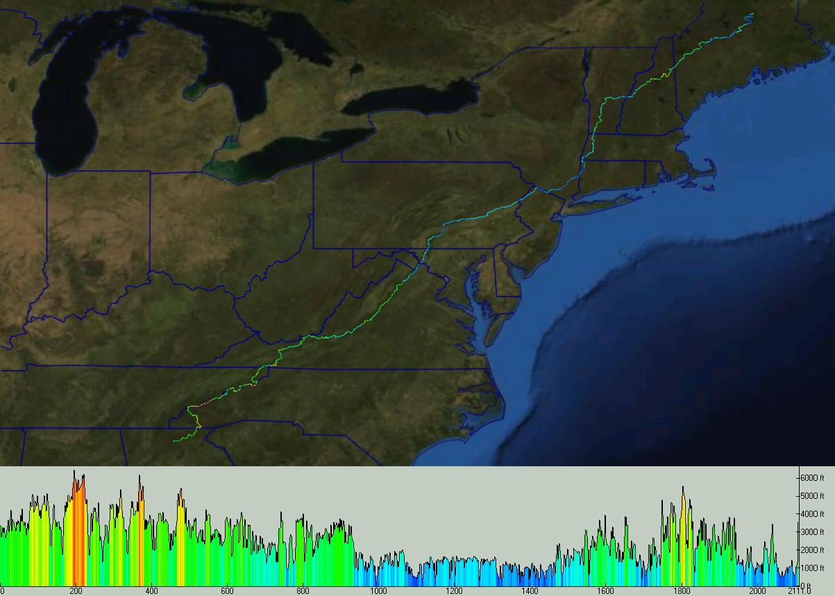
The trail overlay is based on the 2009 ATC centerline data. For the latest mileages and shelter status, please visit the Appalachian Trail Conservancy and see the AT Data Book.

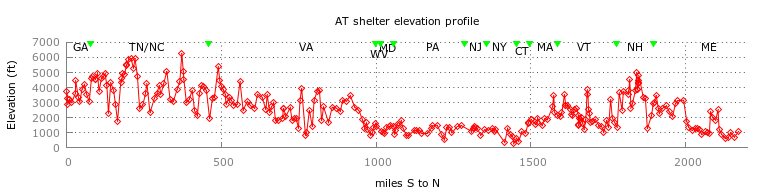
Here is a plot of the elevation profile of the AT shelters. At 6275' Roan High Knob Shelter is the highest shelter on the AT, and Ten Mile River Lean-to is the lowest at 290'. The average distance between shelters is 7.8 miles, and the max distance is 31.2 miles between Kirkridge and Brink Road shelters. Each entry in the table above has an elevation profile of the trail between shelters based on this elevation data.

Smoky Mountains (GSMNP) campsites waypoints, maps for shelters and backcountry campsites

Visits since 1/26/04    © Tom Dunigan
Last modified: Tue, 07 Feb 2012 09:51:25 -0500
For more detailed guide books on the AT, please visit the Ultimate Trail Store. The AT Diamond is a registered service mark of the Appalachian Trail Conservancy.