Appalachian Trail Shelters| WGS84 |
| 35.56635 | -83.64179 |
| 35° 33.981'N | 83° 38.507'W |
| 35° 33' 58.9"N | 83° 38' 30.4"W |
| 17S 260577E 3939064N |
| convert to NAD27 |
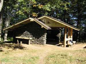
Derrick Knob Shelter 
Waypoint: DerrickKn 35.56635,-83.64179
County/State: Sevier TN
Elevation: 4880' or USGS elevation
190.1 miles from Springer and 2007.3 miles to Katahdin
next shelter south ↓ 6.1 miles. next shelter north ↑ 5.7 miles. all shelters
popup list of
nearby shelters (mileage, bearing) (as the crow flies)
 NOAA weather near shelter
or
wunderground
NOAA weather near shelter
or
wunderground
MAPS
Select one of the following maps to display this waypoint (WGS84).

GPS
These maps, coordinates, and waypoint files are based on recent (2009)
Appalachian Trail
waypoints.
You can often find more information on a particular
shelter by visiting the AT
partners that maintains that section of trail.
For trail mileages between shelters go back to our
list of shelters.
AppalachianTrail.org has
the latest trail conditions, maps, and trail guides.
Additional information:
| Type: Shelter | Capacity: 12 | Fee: No |
| Near AT: Yes | Accuracy: GPS | Information: None |
| USFS Land: No | Maintained by: Smoky Mountain Hiking Club |
Notes: "Spring is 50 yds W (on Tennessee slope)--gb, 56"
USGS quad: THUNDERHEAD MT
Δ elevation profile to next shelter north, cumulative climb/descent, (data provenance)
 make-over Sept. 2007
AT shelters
GSMNP campsites
GSMNP landforms
BSF landforms
TN landforms
 ©
Tom Dunigan TNlandforms.US
©
Tom Dunigan TNlandforms.US