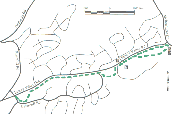
4. Emory Valley Greenway
Description:
This fairly level greenway lies a few feet off Emory Valley Road
and runs through a natural area along a backwater of Melton Hill
Reservoir and along a creek.
Trail surface:
asphalt
Elevation: 798' to 862'
Difficulty: Easy
Handicap Access: No
elevation profile
Distance:
3.1 miles one way (1.7 miles to loop split)
Main Entrances:
Melton Lake Dr at Emory Valley Rd;
Small parking area at Cascade Lane;
Briarcliff Avenue near Food Lion
Uses:
Walk/jog, pets, bicycles, skates/rollerblades
Map
legend/rules
In 2005, the greenway was converted to asphalt and extended along
Emory Valley Road to sidewalk at west end of Briarcliff (dash line on map).
See
a bit of history of Emery Road and
the Emory Valley greenway (2/06) and D. Ray Smith's
Emery Road
history, also see the 1890 TN
topo maps
GreenwaysOakRidge.org
Greenway maps:
map index
North Ridge
Cedar Hill
Pine Grove
Emory Valley
Gallaher Bend
Melton Lake
Big Turtle
Worthington
North Boundary
Wildflower
Haw Ridge
Black Oak Ridge
Google map
Greenways Oak Ridge home