
As a supplement to the landforms of Tennessee, the table above lists various landforms (waterfalls, peaks, balds, rock formations, sinkholes) in the Great Smoky Mountains National Park in Tennessee and North Carolina. Information on each landform includes maps, GPS waypoint (latitude/longitude), and the occasional picture. In the Smokies there are 17 peaks over 6000', 8 balds, 6 arches, 2 large sinkholes, and more than 90 waterfalls. The higest point in the park is Clingmans Dome (6643', Cherokee name: Kuwahi), and the lowest point is along the park boundary with Chilhowee Lake (842'). Some of these landforms are off-trail, contact the Park Rangers regarding off-trail or manway ventures. Corrections and additions are welcomed. For more information see
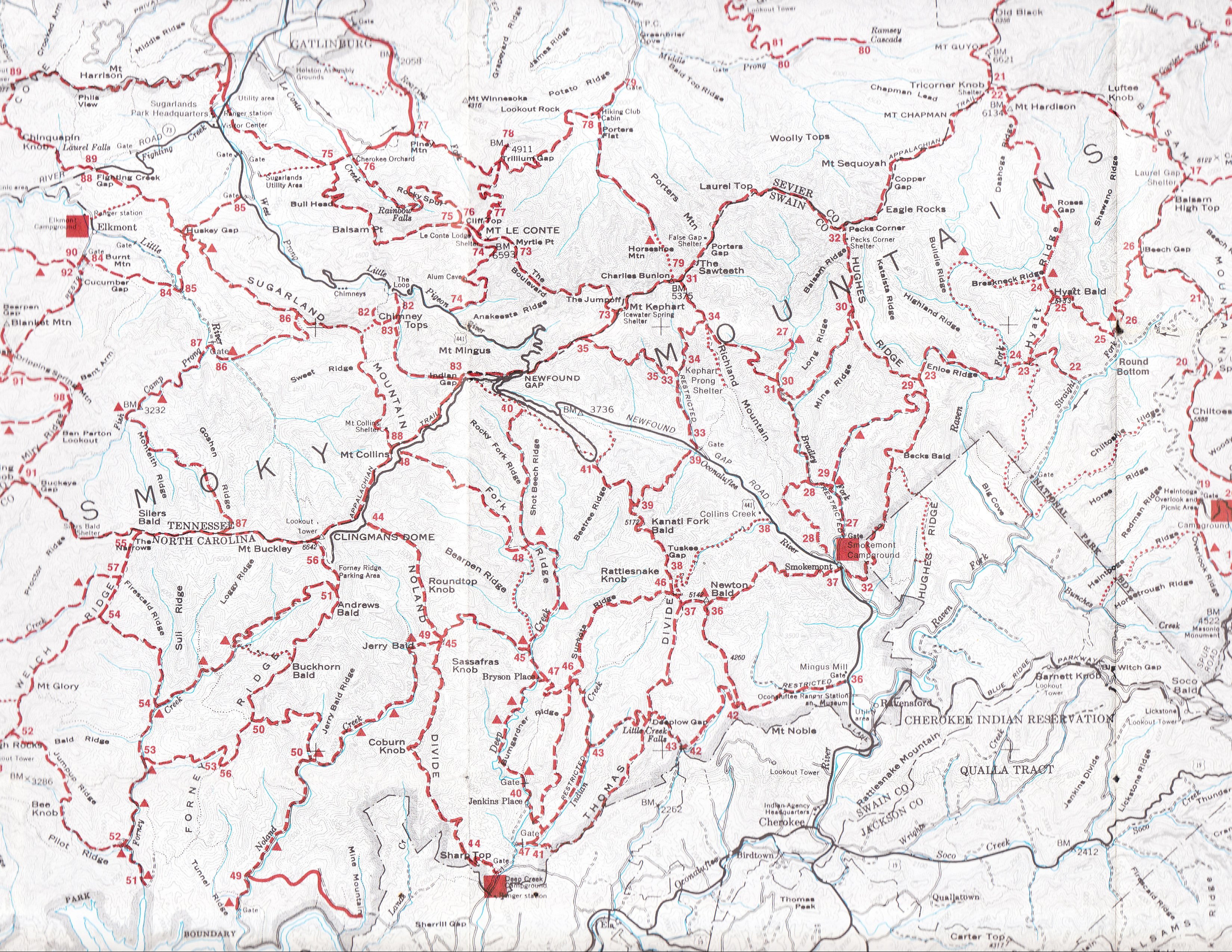
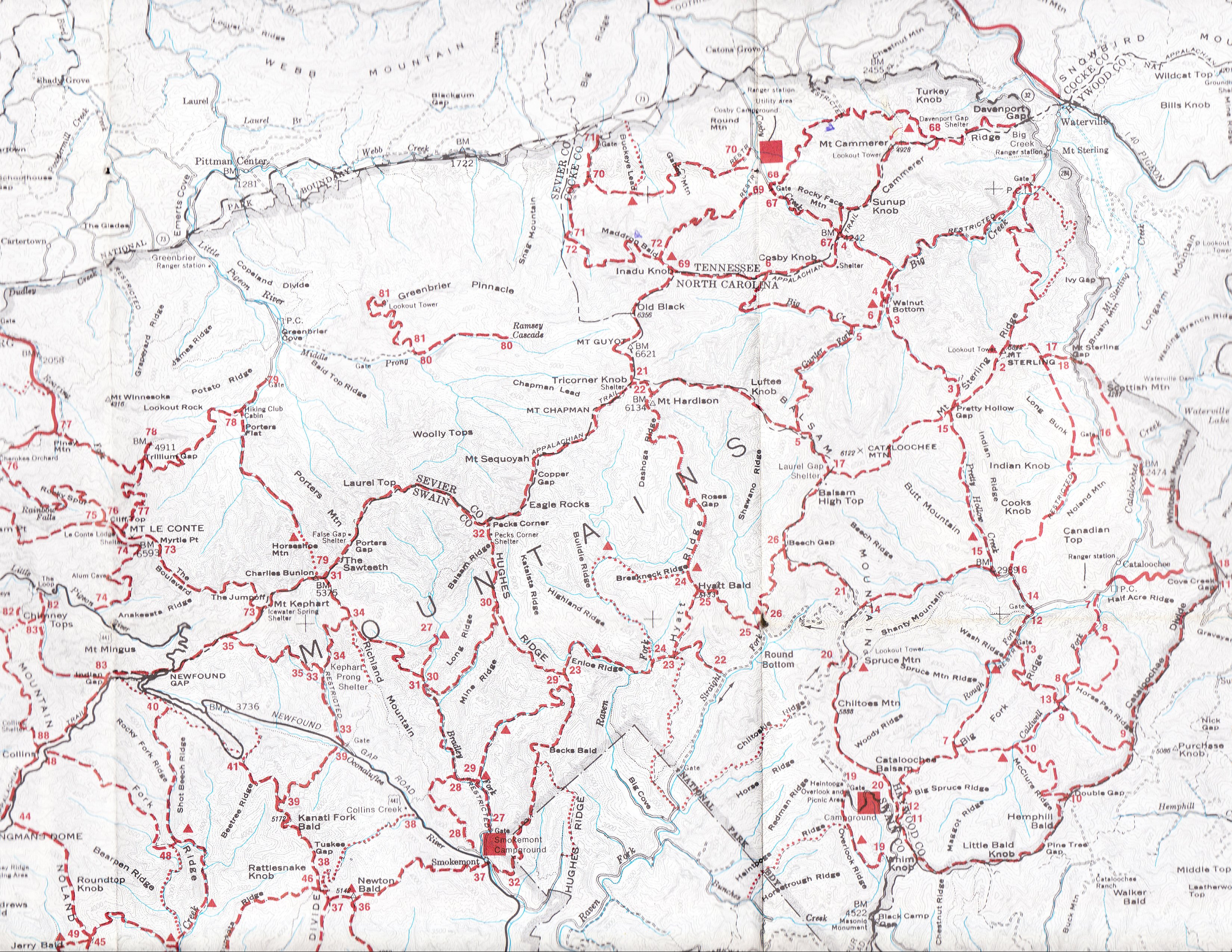
- clickable GSMNP trail map (1997) zoom/pan
- clickable Google ★ map/image/topo ★ with landforms, trails, and campsites or iPhone map
- GSMNP
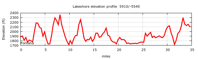
hiking trails mileage, climb, elevation profiles, and map locator
and stream crossings.
Steepest half-mile sections:- Eagle Cr mile 7.3 to 7.8 24%,
- AT mile 20.4 to 20.9 22%,
- Lost Cove mile 1.8 to 2.2 22%,
- Chimneys mile 1.2 to 1.7 22%.
- Google Earth KML file gsmnp.kmz for GSMNP landforms or camp.kmz campsites or trails.kmz trails (2/22/08)
- GSMNP landforms and campsites ESRI map arcgis or leafletjs GSMNP map
- clickable 1964 USGS topo quadrangle map of GSMNP, zoom/pan
- GSMNP park maps (pdf's)
-
 GSMNP campsite locations maps and GPS waypoints for GSMNP
campgrounds, shelters, and backcountry campsites
GSMNP campsite locations maps and GPS waypoints for GSMNP
campgrounds, shelters, and backcountry campsites
- GSMNP GPS waypoints: landforms gsmnp.gpx, campsites camp.gpx, trail heads/junctions trlwpts.gpx, GPS trail tracks
- GSMNP mobile phone Avenza topo maps
- GSMNP road, trail, and campsite closures or twitter
- weather and snow depth at various locations within the Smokies or here or and forecast
- weather at Cove Mountain tower and air quality/weather at Cades Cove or Look Rock or Clingmans Dome
- historical weather data graphs, temperature and precipitation ( Tremont) and weather.com graphs and monthly average at Gatlinburg and Clingmans Dome and here
-
 mountain webcams
GSMNP webcams of Gatlinburg webcams
Newfound Gap webcam
Clingmans Dome webcam
Look Rock (2880') view of Smokies (15 min updates)
Purchase Knob (4900', NC) (looking NE)
WBIR skycam looking at Mt LeConte from west of Gatlinburg
Mt Pisgah (5700') view of Cold Mountain in Shining Rock wilderness
elk cam Hatfield Knob, Campbell County
more mountain web cams - Mt LeConte lodge and daily blog from caretakers
- Tennessee landforms arches, waterfalls, chimneys with maps/waypoints/pics
- brown book:
Hiking Trails of the Smokies
trail descriptions, map, elevation profiles

- 1973 blue book: Hiker's Guide to the Smokies and its map: west middle east
- Hiker's Guide to the Smokies or Hiking Trails of the Great Smoky Mountains
- Day Hiker's Guide To All The Trails In The Smoky Mountains 1060 miles in 75 day hikes
- Smokies geology
- geology studies and maps
- geology of Cades Cove
- Mt LeConte geology and geological map
- geologic maps and geologic map 2013 and more geology maps
- Smoky Mountain caves and geologic resource inventory (2000)
- vegetation maps from UGa study, overstory (pdf) and understory (pdf) pg 24
- Cades Cove cultural resources
- book A Roadside Guide to the Geology of the Great Smoky Mountains National Park
- Survey Bulletin 587 Geology of the Great Smoky Mountains National Park and another
- igneous rock near Mt
Collins (not visually significant)

- locations of springs along the trails and Fittified Spring
- GSMA books and things
- Friends of GSMNP support the park, license plates
- Smoky Mountains Hiking Club and Bob Lochbaum's How far is it gps'n and measurin' the trails
- Carolina Mountain Club hikes GPS route files
- 2/22/08 GSMNP/Lochbaum trails.zip Maptech trail track file (gsmnp.txf) or GPX version trailsgpx.zip or individual trail gpx tracks (gpx)
- 1995 NPS GSMNP GIS data and Maptech smtrails.txf '95 trail track file (1.3 MB)
- Google Earth has a layer with the GSMNP trails, you can add landforms and campsites with the following KML files gsmnp.kmz and camp.kmz or 2/22/08 trails trails.kmz
- Smoky Mountain trails maps and GPS track data from '95 data above (.gpx format)
- smoky mountains trails
- OSM Smoky Mountains map
- 900 miler hike all trails in the GSMNP ( the trails) and an article
- updated Smokies topo maps (geo-reference pdfs) 2013
- historical
maps of the Great Smoky Mountains from Library of Congress
- 1926 topo
- our cross-referenced 1931 topo from 1931 topo maps
- 1949 topo or our lat/lon indexed version
- 1974 Smokies blue book trail/topo map or our lat/lon indexed version or scanned west middle east
- 1980's trail maps
- our cross-referenced 1997 trail map
- Smokies 1999 trail map pdf
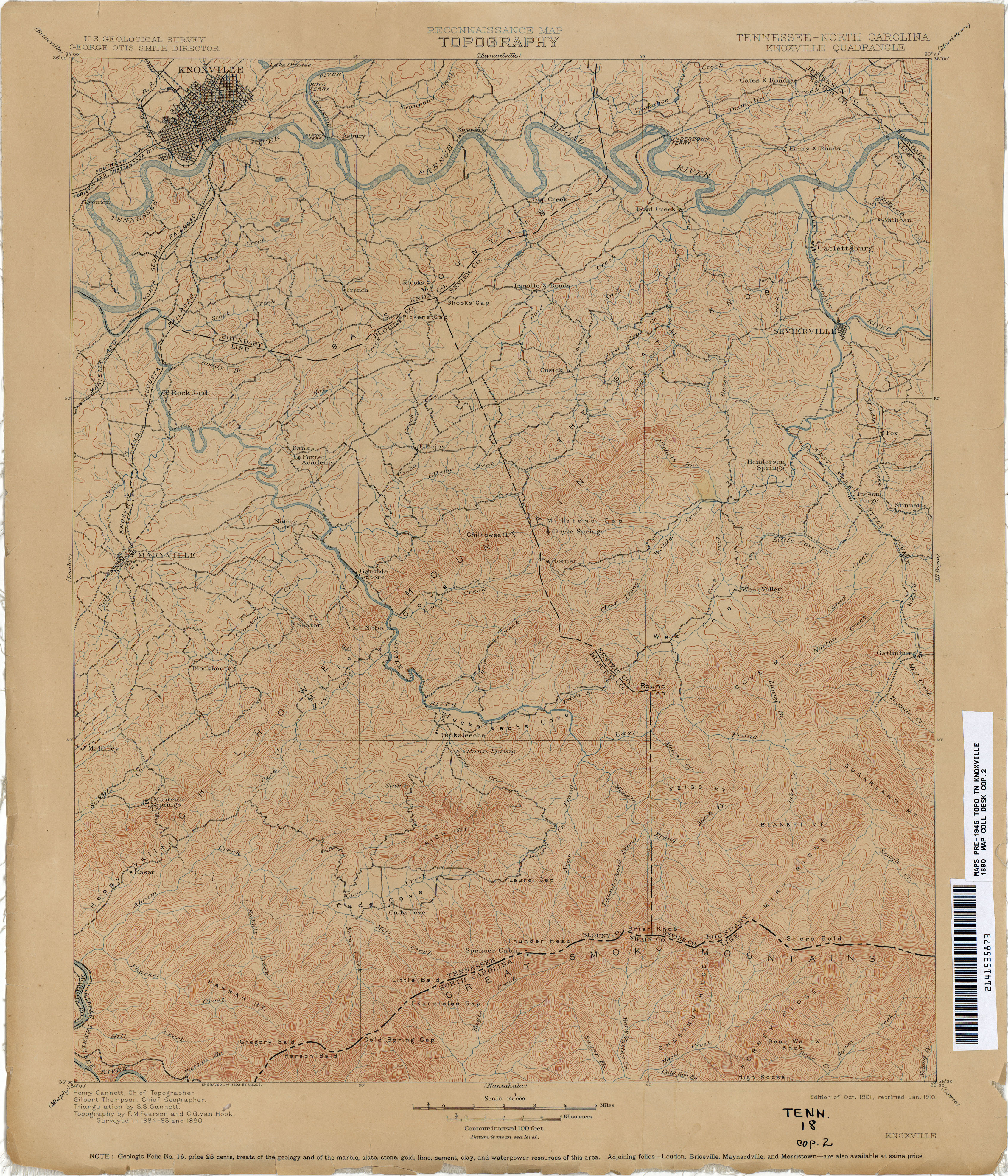
- topo's from the 1890s plus many more ...
- 1890 topo knoxville/smokies and Mt Guyot from Tennessee Historical Topographic Maps
- UT library Smoky Mountain Maps
- USGS topo quads with peaks
- CCPA Cades Cove folks on 1934 map
- Smoky Mountain trail maps and atlas with GPS data or National Geographic map
- Dutch Roth's black&white photos of the Great Smoky Mountains (1920's-)
- Dutch Roths's Tales from the Woods journal/photos of Roth's hikes in the Smokies (1924-1959).
- Kephart's photos
- Garner photos
- 1936 Great Smoky Mountains National park film
- Fontana lake and lake level summer pool 1700', winter level 1640' and boat ramps or google map
- The remotest point in the Smokies (and NC) is at
35.545735,-83.603749 about 6.2 miles from any road or the Fontana
shoreline.
The remotest campsite is
Tricorner shelter, about 5 miles to nearest road.
The remotest point in Tennessee is at
35.570068,-83.591414 about 5.5 miles from any road or
35.688871,-83.262976 (5.3 miles).
Refs: wiki Pole of Inaccessibility, Going remote, algorithm
The furthest point on a trail from a trailhead is at 35.673557,-83.293037 along the AT at Mt Sequoyah, 12.2 miles via Hughes Ridge or Snake Den. - Great Smoky Mountain peaks of 5000' and higher with at least 160' of prominence on Google map
- summitpost.org Great Smoky Mountains
- 12 peaks over 6000' in the Smokies (with prominence of at least 200')
- Which is higher -- Tricorner Knob or Mt Yonaguska? LiDAR knows.
- 2011 Smokies GPS elevation survey and LiDAR
- peaks in the south over 6000', see South Beyond 6000 or peakbagger.com and their peak search
- LiDAR and the phantom peak on Big Cataloochee
- Appalachian Trail TN section and Maptech TN AT track file (zip, txf)
-
 shelter waypoints for all of AT
- the AT in the Smoky Mountains elevation profile mileage profile
- side trails off the AT in the GSMNP
- Appalachian Trail guide through Great Smoky Mountains National Park
- landforms of the Big South Fork (TN/KY) GPS
- GPS info and free pc-to-gps software EasyGPS
- TN peaks 4500' and higher or Google map of TN peaks with greater than 1000' prominence, NC 5000' peaks
- TN peaks over 6000' or county high points and NC county high points
- NC waterfalls google map worlddatabase.com North Carolina
- wayhoo's USGS waypoints in/near GSMNP
- TN/GSMNP lookout towers
and Google map
- Dutch Roth tower photos 1920