Tennessee Landforms -- arches and natural bridges| WGS84 |
| 36.028900 | -84.720600 |
| 36° 1.734'N | 84° 43.236'W |
| 36° 1' 44"N | 84° 43' 14.2"W |
| 16S 705379E 3989558N |
| convert to NAD27 |
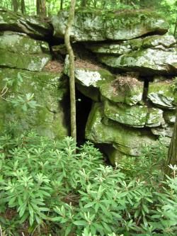
Catoosa Passage 4x7
Waypoint: MGA009 36.028900,-84.720600
County: Morgan landforms of Morgan county
Locale: Catoosa
NABSQNO 16S-705379-3989558
popup list of
nearby landforms (mileage, bearing)
MAPS
Select one of the following maps to display this waypoint (WGS84).
GPS
Remarks:
Passage way in "gravity" arch.
Tennessee landforms
home
arches
waterfalls
rocks
peaks
balds
sinks
lakes
regions
county
GSMNP landforms (TN/NC)
BSF landforms (TN/KY)
or nearby
lookout towers
 ©
Tom Dunigan
©
Tom Dunigan