Tennessee Landforms -- arches and natural bridges| WGS84 |
| 36.545493 | -84.800010 |
| 36° 32.73'N | 84° 48.001'W |
| 36° 32' 43.8"N | 84° 48' 0.1"W |
| 16S 696920E 4046706N |
| convert to NAD27 |
Second Chance Arch 14x5
Waypoint: PIA017 36.545493,-84.800010
County: Pickett landforms of Pickett county
Locale: state park
NABSQNO 16S-696920-4046706
popup list of
nearby landforms (mileage, bearing)
MAPS
Select one of the following maps to display this waypoint (WGS84).
GPS
Remarks:
References: JNAD:TENN-14, C/P:27
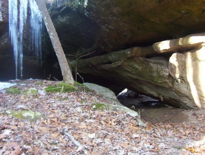 photo courtesy Keith Garnes
Tennessee landforms
home
arches
waterfalls
rocks
peaks
balds
sinks
lakes
regions
county
GSMNP landforms (TN/NC)
BSF landforms (TN/KY)
or nearby
lookout towers
 ©
Tom Dunigan
©
Tom Dunigan