Tennessee Landforms -- waterfalls| WGS84 |
| 36.126700 | -82.322500 |
| 36° 7.602'N | 82° 19.35'W |
| 36° 7' 36.1"N | 82° 19' 21"W |
| 17S 380994E 3998811N |
| convert to NAD27 |
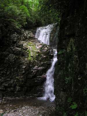
Rock Creek Falls 50'
Waypoint: UCF004 36.126700,-82.322500
County: Unicoi landforms of Unicoi county
Locale: Cherokee National Forest
popup list of
nearby landforms (mileage, bearing)
MAPS
Select one of the following maps to display this waypoint (WGS84).
GPS
Remarks:
CNF trail 148. also see middle and lower falls.
Tennessee landforms
home
arches
waterfalls
rocks
peaks
balds
sinks
lakes
regions
county
GSMNP landforms (TN/NC)
BSF landforms (TN/KY)
or nearby
lookout towers
 ©
Tom Dunigan
©
Tom Dunigan