Tennessee Landforms -- waterfalls| WGS84 |
| 35.662860 | -85.349422 |
| 35° 39.772'N | 85° 20.965'W |
| 35° 39' 46.3"N | 85° 20' 57.9"W |
| 16S 649400E 3947811N |
| convert to NAD27 |
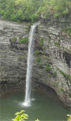
Rockhouse Falls 125'
Waypoint: VBF007 35.662860,-85.349422
County: VanBuren landforms of VanBuren county
Locale: state park
popup list of
nearby landforms (mileage, bearing)
MAPS
Select one of the following maps to display this waypoint (WGS84).
GPS
Remarks:
Tennessee landforms
home
arches
waterfalls
rocks
peaks
balds
sinks
lakes
regions
county
GSMNP landforms (TN/NC)
BSF landforms (TN/KY)
or nearby
lookout towers
 ©
Tom Dunigan
©
Tom Dunigan