Tennessee Landforms -- waterfalls| WGS84 |
| 35.924022 | -85.383568 |
| 35° 55.441'N | 85° 23.014'W |
| 35° 55' 26.5"N | 85° 23' 0.8"W |
| 16S 645831E 3976729N |
| convert to NAD27 |
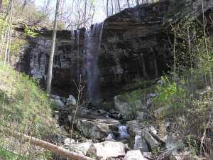
Wildcat Creek Falls 30'
Waypoint: WHF018 35.924022,-85.383568
County: White landforms of White county
popup list of
nearby landforms (mileage, bearing)
MAPS
Select one of the following maps to display this waypoint (WGS84).
GPS
Remarks:
wet-weather falls
Tennessee landforms
home
arches
waterfalls
rocks
peaks
balds
sinks
lakes
regions
county
GSMNP landforms (TN/NC)
BSF landforms (TN/KY)
or nearby
lookout towers
 ©
Tom Dunigan
©
Tom Dunigan