The Cherokee National Forest lies along the western slopes of the Appalachians in East Tennessee. The Forest Service roads are gravel and dirt and are open to bicycles -- even the gated gravel roads. Most roads are graded, but there are some designated "off-road vehicle/4WD" roads that are rougher and steeper. Horse trails are open to mountain bikers. There are a few single-track trails open to bicycles, but bicycles are not permitted on hiking trails. Check with the Forest Service office (423-476-9700) for current access restrictions.
The Ocoee area is an active outdoors area -- kayaking, rafting, rock climbing, hiking, and mountain biking. Numerous outfitters provide rafting services, and there are also mountain bike rentals.
See area trail map or Clemmer trails, or Tanasi trails. Also visit chattbike.com's page.
Description: Off of TN 30, you can ride the gravel FR68 ("Kimsey Highway") from Archville (Greasy Creek, 1000') 15 miles to Harbuck (1760') on TN 68, climbing to 3000' at the spur to Little Frog mountain (3342'). From Little Frog mountain you can make a 20 mile loop with FR23 and FR80, or a longer loop (28 miles) down to the Hiwasee (1020') with FR66 (5 miles) and FR23. The most scenic section of FR23 is its descent through the Wolf Creek canyon to the Hiwassee. The access to FR23 from TN68 is from Turtletown school. A swinging bridge across the Hiwasse joins FR236 (1650', 4 miles) and FR108 (paved, 5 miles) at the powerhouse (860'). FR103 is 12 miles from TN30 to FR23 with access to Lost Creek campground.
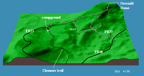
The paved Forest Service Road FR77 is a scenic 7 mile climb from US 64 (880') to the Chilhowee campground and recreation area (1880'), see 3-D map (24K). At mile 5.8 there is a gravel 3 mile descent to TN 314 down the northwest face of the mountain. FR 77 changes to gravel at the campground and continues 5 miles to the Oswald Dome towers (3000'), with intersections to FR 185 at gravel mile 2. At mile 4, FR 77 descends 5.4 miles to the right to TN 30 (1040'). FR 185 descends 3.9 miles to its junction (1100') with FR 77.
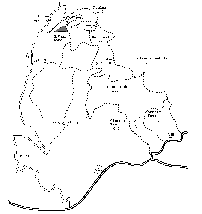
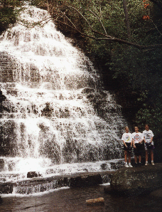
From the campground (1880') one can ride over 20 miles of single track including the Azalea trail (2 miles), Arbutus trail (0.7), Slick Rock (5.1), and Red Leaf trail (0.25) (see clemmer map). The Clemmer trail (6 miles) descends 1.4 miles past Benton Falls (1600') ( picture, 66K) to US 64 (870') just west of the junction with TN 30. Loops can be made with the Clemmer trail using the gnaryly Clear Creek trail (5.5 miles), or Rim Rock trail (1 mile), or Slickrock trails to the west. One can avoid the highways by using the purple blaze crossover tail (1.4 miles) connecting the base of Clemmer with Clear Creek.
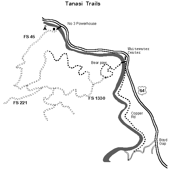
The Tanasi trail complex is being developed along the Ocoee with the Whitewater Center as the hub (see Tanasi map). From the center (1200'), the Copper Road trail goes upstream 2.5 miles along the east bank of the river to the access road (1380') to Ocoee Dam No. 3. This is an easy ride that follows an 1850's wagon road. Bear Paw loop is a two-mile single-track that starts from the pedestrian bridge across from the Center and climbs 300' to a junction with FS 1330. There is a 6.2 mile loop that includes FR 45 from Ocoee No. 3 power house and FR 1330. This trail complex will eventually include over 40 miles of mountain bike trails.
There are additional Forest Service roads south of the Ocoee around Big Frog (FR 221, FR 62, FR 55) including Sylco Ridge (FR 302T, 2.3 miles) and Jake Branch (FR 101, 4.2 miles) accessed via Cookson/Baker Creek roads west of Parksville. There are other rides north of the Hiwassee (Starr Mtn ) and in the Tellico area.
More CNF mountain bike trails