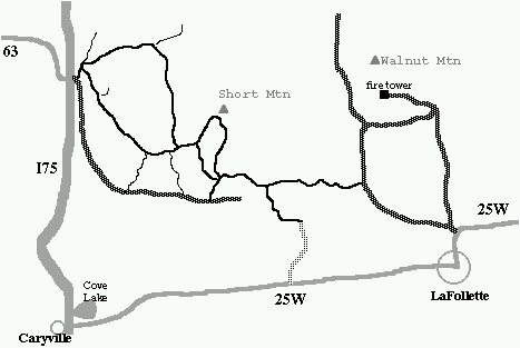
Click here for rough map. Good luck.
Description: Royal Blue (or Koppers wildlife mgt. area) is a 50,000 acre multiuse (hunting, off-road vehicles) wilderness. It is laced with jeep roads and ATV trails and is not recommended for the navigationally impaired. Riding is restricted to roads marked with green paint. TWRA notes that it has "hazards associated with mining." From I75, you can ride 10 miles to the Walnut Mountain fire tower (2832'), or make a loop via Short Mtn. Start by climbing north, or follow the gravel road south, paralleling I75. Nice waterfall on Meadow Creek.
Since the area is frequented by off-road vehicles, trails/roads can be very muddy. Ride during a dry season. During hunting season (Oct-Dec), try not to look like a deer. Actually, TWRA requires 500 sq. inches of fluorescent orange be worn on upper torso Oct-Dec. See TWRA hunt schedules for April and May closure dates for turkey hunts also see TWRA WMA hunt schedule.
Also visit the nearby Caryville trails (Royal Blue west). See Dan's North Cumblerand Trail kml file
Recent Walnut Mountain hourly weather data.